
NOAA says La Niña in the Pacific is over
The La Niña event that overtook the tropical Pacific this past winter is officially over, according to the latest update from NOAA’s Climate Prediction Center. La Niña’s signatureof heavier-than-usual rainfall in the western part of the basin has tapered off, and the cool surface waters in the central part of the basin are dissipating.

This animation tracks the fall emergence, winter peak, and spring decay of the ocean half of the La Niña climate phenomenon. It shows monthly sea surface temperatures compared to average (1981-2010) from August 2017 through April 2018. Places where temperatures were up to 9 degrees cooler than average are blue; places where they were up to 9 degrees warmer than average are orange and red.
Why do U.S. climate forecasters pay so much attention to a pattern that operates in the remote tropical Pacific? Because the Pacific is the world’s biggest ocean, and disruptions to its climate have a long reach. The seesawing changes in tropical rainfall, winds, and ocean temperature that accompany La Niña and its warm-phase partner, El Niño, trigger a cascade of potentially predictable impacts on seasonal climate in the United States and beyond.
But, using a difference color scheme, we get a different impression:

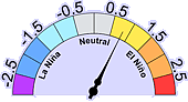
And our ENSO 3.4 region indicator shows the cool side of neutral.
Will La Niña return? Watch and wait.
via Watts Up With That?
May 11, 2018 at 02:59PM
