Month: June 2018

Inconvenient: Antarctica’s Ice Sheet May Be More Durable Than We Thought

On the same day that WaPo and other alarmist media outlets were wailing about a small loss in Antarctic ice balance, another study came out. This study found that the East Antarctic Ice Sheet has survived higher temperatures than we are experiencing now.

Mt. Erebus rising above the ice-covered continent. Credit: Ted Scambos & Rob Bauer, NSIDC

From PM:

Summary:

  • Scientists studied the Pliocene epoch, which happened a few million years ago.
  • Temperatures were a little warmer then, so the epoch could be a good preview of a warmer Earth.
  • They found Antarctic ice was more prevalent back then than we’d believed.

One of the biggest potential dangers of increasing climate change is sea level rise caused by the melting of the polar ice caps. As our planet heats up, large ice sheets in Greenland and Antarctica will melt, potentially triggering several feet of increased sea level rise. If the entire Antarctic ice sheet melts into the ocean, it could lead to dozens of feet of sea level rise, likely enough to wipe out entire cities.

Of course, it’s important to remember that ice sheets are complex and predicting how they will react is difficult—there’s a wide range of possibilities. Perhaps the best way for scientists to predict how ice sheets will behave in the future is by learning how they behaved in the past, so one group of scientists traveled to the East Antarctic Ice Sheet to learn its history.

Specifically, the researchers were interested in what happened to the ice sheet during the Pliocene epoch, the geologic period from about 5.4 million years ago to around 2.5 million. During the Pliocene, global temperatures were a few degrees warmer than they are today, which means this era is a good model for what our world might look like in a few decades, if climate change remains unchecked.

To determine just what happened to the ice sheet during this period, the researchers drilled deep into the rock beneath it. The scientists were looking for samples of certain isotopes, beryllium-10 and aluminum-26. These particular isotopes are created from the impact of cosmic rays from space. When these cosmic rays hit the atoms in the soil, they trigger atomic reactions that produce these isotopes.

The key fact here is that cosmic rays can’t penetrate ice. If there was ice over the ground during the Pliocene, the cosmic rays wouldn’t have reached the ground and these isotopes shouldn’t be present in the soil. But if the ice sheet melted significantly, the researchers would find higher levels of these isotopes.

“Based on this evidence from the Pliocene, today’s current carbon dioxide levels are not enough to destabilize the land-based ice on the Antarctic continent,” said study author Jeremy Shakun.

Full story here


The study: https://www.nature.com/articles/s41586-018-0155-6

Minimal East Antarctic Ice Sheet retreat onto land during the past eight million years

Abstract

The East Antarctic Ice Sheet (EAIS) is the largest potential contributor to sea-level rise. However, efforts to predict the future evolution of the EAIS are hindered by uncertainty in how it responded to past warm periods, for example, during the Pliocene epoch (5.3 to 2.6 million years ago), when atmospheric carbon dioxide concentrations were last higher than 400 parts per million. Geological evidence indicates that some marine-based portions of the EAIS and the West Antarctic Ice Sheet retreated during parts of the Pliocene1,2, but it remains unclear whether ice grounded above sea level also experienced retreat. This uncertainty persists because global sea-level estimates for the Pliocene have large uncertainties and cannot be used to rule out substantial terrestrial ice loss3, and also because direct geological evidence bearing on past ice retreat on land is lacking. Here we show that land-based sectors of the EAIS that drain into the Ross Sea have been stable throughout the past eight million years. We base this conclusion on the extremely low concentrations of cosmogenic 10Be and 26Al isotopes found in quartz sand extracted from a land-proximal marine sediment core. This sediment had been eroded from the continent, and its low levels of cosmogenic nuclides indicate that it experienced only minimal exposure to cosmic radiation, suggesting that the sediment source regions were covered in ice. These findings indicate that atmospheric warming during the past eight million years was insufficient to cause widespread or long-lasting meltback of the EAIS margin onto land. We suggest that variations in Antarctic ice volume in response to the range of global temperatures experienced over this period—up to 2–3 degrees Celsius above preindustrial temperatures4, corresponding to future scenarios involving carbon dioxide concentrations of between 400 and 500 parts per million—were instead driven mostly by the retreat of marine ice margins, in agreement with the latest models5,6.

via Watts Up With That?

https://ift.tt/2ybxaad

June 14, 2018 at 04:12PM

Blinded by Antarctica Reports

Special snow goggles for protection in polar landscapes.

Someone triggered Antarctica for this week’s media alarm blitz.

Antarctic ice loss increases to 200 billion tonnes a year – Climate Action

Antarctica is now melting three times faster than ever before – Euronews

Antarctica is shedding ice at an accelerating rate – Digital Journal

Al Gore Sounds the Alarm on 0.3 inches of Sea Level Rise from Ice Sheets- Daily Caller

Antarctica is losing an insane amount of ice. Nothing about this is good. – Fox News
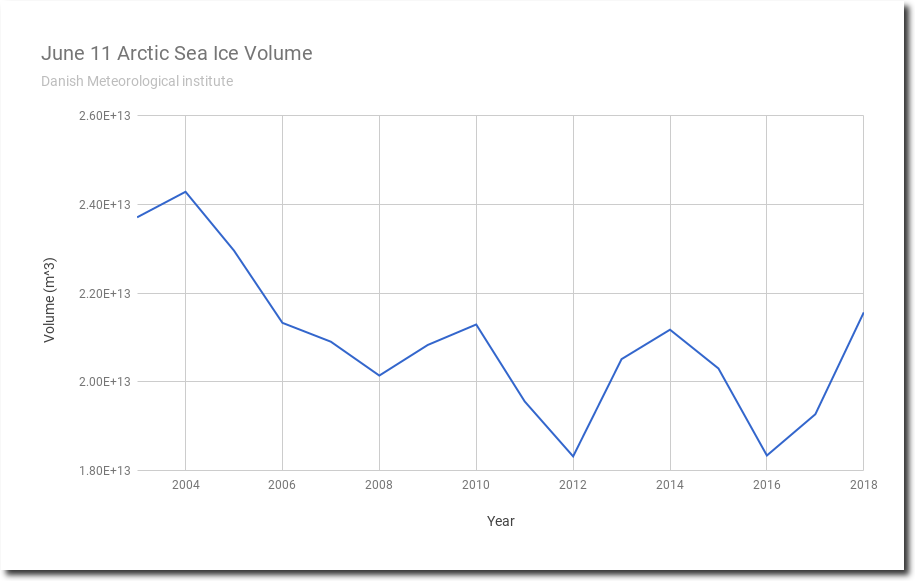
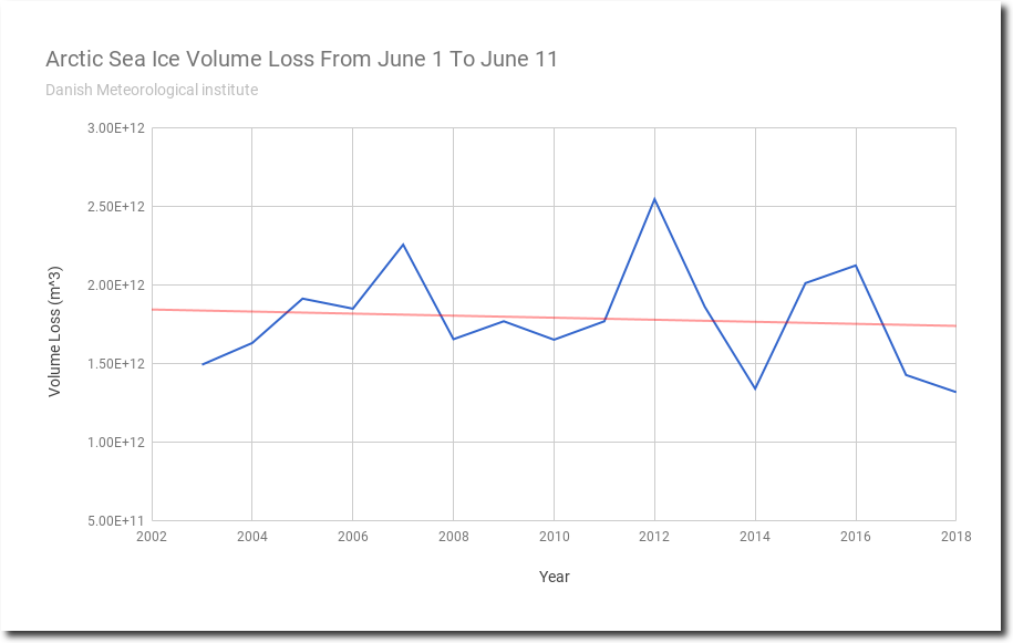
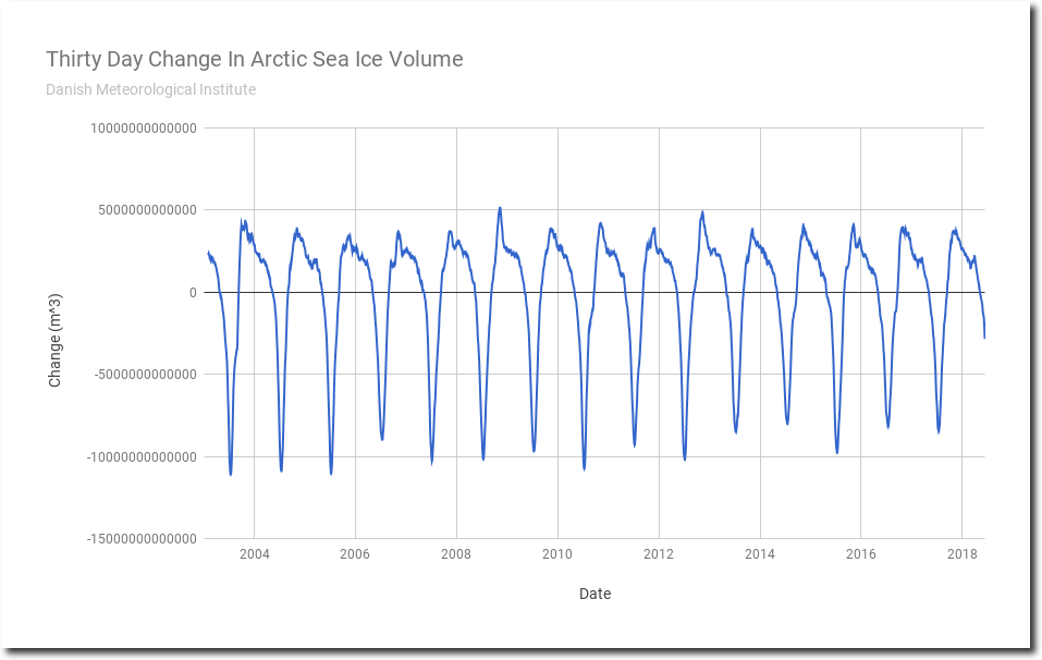
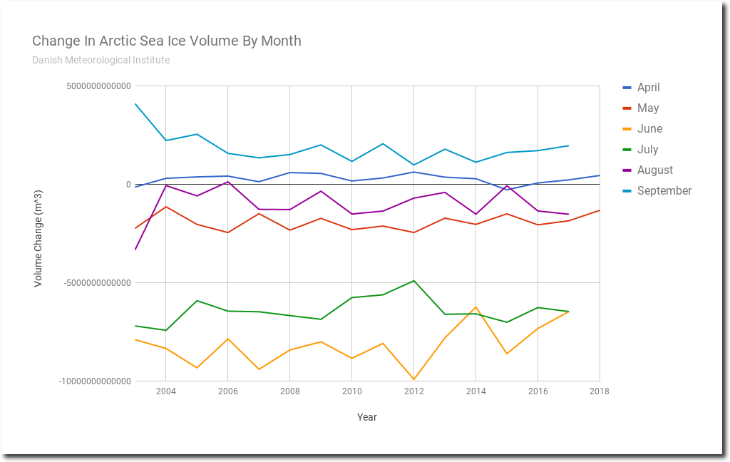
Looks like it’s time yet again to play Climate Whack-A-Mole.  That means stepping back to get some perspective on the reports and the interpretations applied by those invested in alarmism.

Antarctic Basics

The Antarctic Ice Sheet extends almost 14 million square kilometers (5.4 million square miles), roughly the area of the contiguous United States and Mexico combined. The Antarctic Ice Sheet contains 30 million cubic kilometers (7.2 million cubic miles) of ice. (Source: NSIDC: Quick Facts Ice Sheets)

The Antarctic Ice Sheet covers an area larger than the U.S. and Mexico combined. This photo shows Mt. Erebus rising above the ice-covered continent. Credit: Ted Scambos & Rob Bauer, NSIDC

The study of ice sheet mass balance underwent two major advances, one during the early 1990s, and again early in the 2000s. At the beginning of the 1990s, scientists were unsure of the sign (positive or negative) of the mass balance of Greenland or Antarctica, and knew only that it could not be changing rapidly relative to the size of the ice sheet.

Advances in glacier ice flow mapping using repeat satellite images, and later using interferometric synthetic aperture radar SAR methods, facilitated the mass budget approach, although this still requires an estimate of snow input and a cross-section of the glacier as it flows out from the continent and becomes floating ice. Satellite radar altimetry mapping and change detection, developed in the early to mid-1990s allowed the research community to finally extract reliable quantitative information regarding the overall growth or reduction of the volume of the ice sheets.

By 2002, publications were able to report that both large ice sheets were losing mass (Rignot and Thomas 2002). Then in 2003 the launch of two new satellites, ICESat and GRACE, led to vast improvements in one of the methods for mass balance determination, volume change, and introduced the ability to conduct gravimetric measurements of ice sheet mass over time. The gravimetric method helped to resolve remaining questions about how and where the ice sheets were losing mass. With this third method, and with continued evolution of mass budget and geodetic methods it was shown that the ice sheets were in fact losing mass at an accelerating rate by the end of the 2000s (Veliconga 2009, Rignot et al. 2011b).

Contradictory Findings

NASA Study: Mass Gains of Antarctic Ice Sheet Greater than Losses

A new 2015 NASA study says that an increase in Antarctic snow accumulation that began 10,000 years ago is currently adding enough ice to the continent to outweigh the increased losses from its thinning glaciers.

The research challenges the conclusions of other studies, including the Intergovernmental Panel on Climate Change’s (IPCC) 2013 report, which says that Antarctica is overall losing land ice.

According to the new analysis of satellite data, the Antarctic ice sheet showed a net gain of 112 billion tons of ice a year from 1992 to 2001. That net gain slowed to 82 billion tons of ice per year between 2003 and 2008.

“We’re essentially in agreement with other studies that show an increase in ice discharge in the Antarctic Peninsula and the Thwaites and Pine Island region of West Antarctica,” said Jay Zwally, a glaciologist with NASA Goddard Space Flight Center in Greenbelt, Maryland, and lead author of the study, which was published on Oct. 30 in the Journal of Glaciology. “Our main disagreement is for East Antarctica and the interior of West Antarctica – there, we see an ice gain that exceeds the losses in the other areas.” Zwally added that his team “measured small height changes over large areas, as well as the large changes observed over smaller areas.”

Scientists calculate how much the ice sheet is growing or shrinking from the changes in surface height that are measured by the satellite altimeters. In locations where the amount of new snowfall accumulating on an ice sheet is not equal to the ice flow downward and outward to the ocean, the surface height changes and the ice-sheet mass grows or shrinks.

Snow covering Antarctic peninsula.

Keeping Things in Perspective

Such reports often include scary graphs like this one and the reader is usually provided no frame of reference or context to intrepret the image.  First, note the ice mass increased just recently before it declined.  And various methods of measuring and analyzing give different results, as indicated by the earlier section. Secondly, the chart is showing cumulative loss of mass arising from a average rate of 100 GT lost per year since 2002.

Most importantly is understanding the fluxes in proportion to the Antarctic Ice Sheet.  Let’s do the math.  Above it was stated Antarctica contains ~30 million cubic kilometers of ice volume.  One km3 of water is 1 billion cubic meters and weighs 1 billion tonnes, or 1 gigatonne.  So Antarctica has about 30,000,000 gigatonnes of ice.  Since ice is slightly less dense that water, the total should be adjusted by 0.92 for an estimate of 27.6 M Gts of ice comprising the Antarctic Ice Sheet.

So in the recent decade, an average year went from 27,600,100 Gt to 27,600,000, according to that analysis.  Other studies range from losing 200 Gt/yr to gaining 100 Gt/yr.

Even if Antarctica lost 200 Gt/yr. for the next 1000 years, it would only approach 1% of the ice sheet.

By all means let’s pay attention to things changing in our world, but let’s also notice the scale of the reality and not make mountains out of molehills.

Let’s also respect the scientists who study glaciers and their subtle movements over time (“glacial pace”).  Below is an amazing video showing the challenges and the beauty of working on Greenland Glacier.

From Ice Alive: Uncovering the secrets of Earth’s Ice

For more on the Joys of Playing Climate Whack-A-Mole 

via Science Matters

https://ift.tt/2MoXQY2

June 14, 2018 at 02:04PM

Scotland – Winter deaths highest in 30 years

“The number of people who died in Scotland over the winter months was the highest in more than 30 years, according to official figures.”

There were 17,771 deaths registered in the first three months of this year – 2,060 more than in the same period of 2017 and the highest since 1986.

See more:
https://www.bbc.com/news/uk-scotland-scotland-politics-44468655

Thanks to Jay Hope for this link

“Even the old BBC had to give this a mention, although they are trying to fudge it by mentioning other health issues,” says Jay.

The post Scotland – Winter deaths highest in 30 years appeared first on Ice Age Now.

via Ice Age Now

https://ift.tt/2LRiuPA

June 14, 2018 at 01:40PM

Visualizing Why Arctic Alarmists Are Doomed

Arctic sea ice is melting at the slowest rate on record, and volume is the highest in thirteen years.

Spreadsheet    Data

The graphs below show why this is a huge problem for climate alarmists. Due to recent cold summers in the Arctic, peak melt rates have dropped over the past 15 years. The Arctic used to regularly see months which lost over a trillion tons of ice, but recent years have generally had much slower melt rates.

But here is the real problem for alarmists.  The only months where significant melting occurs are June and July. By August, the sun is too low in the sky to melt much ice – and during August 2006 the Arctic actually gained sea ice.

June is the peak melt month, and this June is seeing record slow melt. Short of an asteroid strike, there is zero chance of an ice-free Arctic this year, or any time in the foreseeable future. Climate alarmists suffer from two main problems.

  1. They don’t understand that the Earth is round, and that by mid-August the Sun is too low in the sky to melt ice near the North Pole.
  2. They focus on nearly meaningless sea ice extent graphs.

Extent graphs frequently show a large decline in August because early winter storms break up thin ice around the edges. This makes Arctic alarmists feel very relieved, but has little effect on the ice volume.  But no one ever said climate alarmists have much going on upstairs.

The Argus-Press – Google News Archive Search

via The Deplorable Climate Science Blog

https://ift.tt/2JSAKdT

June 14, 2018 at 01:34PM