
By Paul Homewood
It did not take long for the climate mafia to emerge from the woodwork:

Hurricane Michael exploded in intensity this week, from a rather nondescript tropical depression Sunday with winds of 35 mph to a Category 4 monster Wednesday with 155 winds.
When it hit land, it became the most powerful hurricane on record to slam Florida’s Panhandle and the third-strongest U.S. landfall of all time.
Along with other weather factors, Michael’s rapid intensification was fuelled in part by unusually warm sea water in the Gulf of Mexico. Warm water of at least 80 degrees fuels hurricanes, and the water in the eastern Gulf this week was as much as 4 to 5 degrees warmer than normal.
Although random weather patterns certainly played a role, the warm waters in the Gulf have a “human fingerprint” of climate change, according to National Oceanic and Atmospheric Administration climate and hurricane expert Jim Kossin.
Penn State University climatologist Michael Mann told ThinkProgress that "once again we see a storm undergoing extreme rapid intensification over unusually warm ocean waters. We saw this pattern last year with Harvey and earlier this year with Florence and now, with my namesake, Michael.”
I wonder what they think caused Camille in 1969, a hurricane many more times powerful than Michael, and one which also landed not far away on the Gulf Coast?
Below is the NWS account:
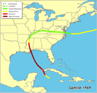
Hurricane Camille
August 17, 1969
Late in the evening on August 17 in 1969, Hurricane Camille made landfall along the Mississippi Gulf Coast near Waveland. Camille is one of only THREE Category 5 hurricanes ever to make landfall in the United States, the other two being the 1935 Labor Day Hurricane in the Florida Keys and Hurricane Andrew, which hit the Miami, FL area in 1992. Camille also ranks as the 2nd most intense hurricane (ranked by pressure) to strike the continental US with the 2 hurricanes listed above ranked 1 and 3, respectively. The actual maximum sustained winds are not known, as the hurricane destroyed all the wind-recording instruments in the landfall area. Re-analysis data showed peak winds of 175mph along the coast. A devastating storm tide of 24.6 feet occurred west of our area in Pass Christian, MS.
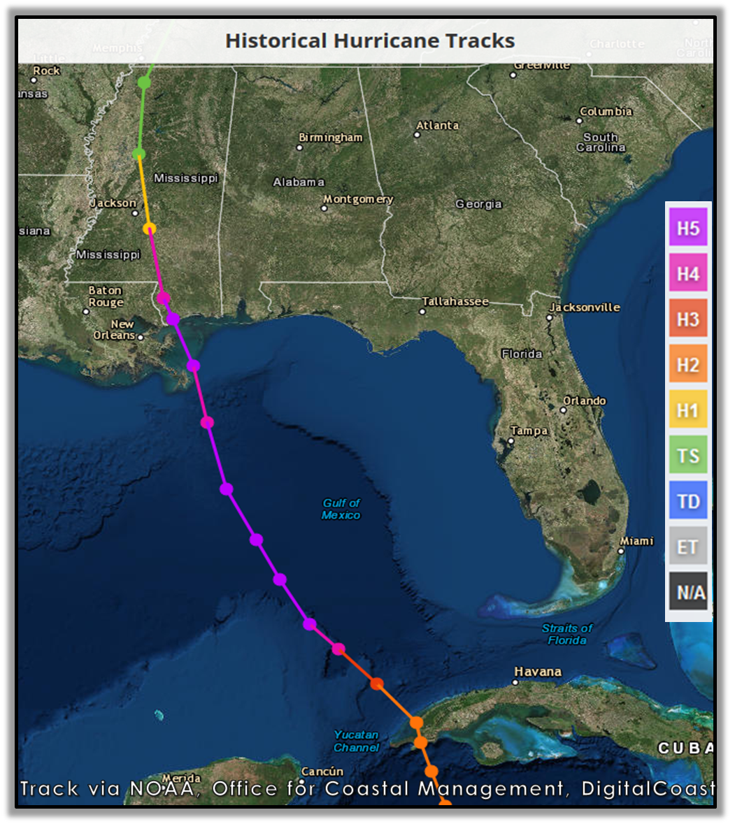
Photo courtesy of NOAA, Office for Coastal Management, DigitalCoast
Hurricane Camille impacted the entire region, especially counties across southeast Mississippi and southwest Alabama in our area. Counties in southeast Mississippi had the greatest damage due to the proximity to Camille’s path across the state of Mississippi. Winds gusted to 100mph across much of southern Mississippi. Moderate wind damage extended inland to Stone and George Counties in Mississippi with minor damage further inland, mainly restricted to fallen trees and powerlines. Further east from the path of Camille, hurricane force winds were reported on Dauphin Island and along the coast of Grand Bay and Portersville Bay. No reporting station across the Florida panhandle observed hurricane force winds.
Most property damage along the immediate coast was caused by high tides. The tide was estimated at 10 feet above the astronomical tide on the night of the 17th through the 18th of August across Dauphin Island coastal Mobile County. Further east, the storm tide was estimated at 6.3 feet above astronomical tide in the Pensacola area, 4.5 feet above astronomical tide across coastal Santa Rosa County and 4.0 feet above astronomical tide across coastal Okaloosa County.
The greatest damage across our area was found along Dauphin Island and along the coast and northward to the Mobile and Prichard areas (in addition to all of southeast Mississippi). Damage consisted of roof damage, partial destruction of buildings, fallen trees and washed out roads across Mobile and Baldwin Counties in southwest Alabama and Stone and George Counties in southeast Mississippi. Powerlines and trees were down across the entire area.
Crop damage was extensive across southeast Mississippi with the total destruction of many tung and pecan orchards. Crop damage across south Alabama was limited to Baldwin, Mobile and western Washington Counties. Pecans, soybean and corn crops were damaged or destroyed. Pecan damage was extensive and approximately 20,000 acres of corn was flattened. It was estimated that 90% of crop damage across the area was due to the wind while 10% was due to the rain. Total property damage for the Florida panhandle, including beach erosion and crop losses, were estimated near 1/2 million dollars (1969 value, not current conversion value) with the major portion of the damage in Escambia and Santa Rosa Counties.
Based on preliminary data from the NWS, here is a brief timeline of the damage and path of Camille:
August 17, 1969
450pm – Hangar wall blown down at the Fairhope Airport in Fairhope, AL
530pm – Tornado reported in Waynesboro, MS
600pm – Streets completely covered with water in Bayou La Batre, AL
630pm – Tornado reported in Pensacola, FL earlier in the afternoon
930pm – Violent winds observed along coast
1000pm – 62mph wind observed in Mobile, AL
1130pm – Power lines down throughout Mobile County, AL
August 18, 1969
1245am – Eye of Camille moved over McHenry, MS
120am – 74mph wind observed in Mobile, AL
https://www.weather.gov/mob/camille
Camille however was not finished after making landfall, as it was to carve a course inland, before re-emerging through Virginia:
This powerful, deadly, and destructive hurricane formed just west of the Cayman Islands on August 14. It rapidly intensified and by the time it reached western Cuba the next day it was a Category 3 hurricane. Camille tracked north-northwestward across the Gulf of Mexico and became a Category 5 hurricane on August 16. The hurricane maintained this intensity until it made landfall along the Mississippi coast late on the 17th. Camille weakened to a tropical depression as it crossed Mississippi into western Tennessee and Kentucky, then it turned eastward across West Virginia and Virginia. The cyclone moved into the Atlantic on August 20 and regained tropical storm strength before becoming extratropical on the 22nd.
A minimum central pressure of 909 millibars (26.84 inches of mercury) was reported in Bay St. Louis, Mississippi, which makes Camille the second most intense hurricane of record to hit the United States. The actual maximum sustained winds will never be known, as the hurricane destroyed all the wind-recording instruments in the landfall area. The estimates at the coast are near 200 mph. Columbia, Mississippi, located 75 miles inland, reported 120 mph sustained winds. A storm tide of 24.6 ft occurred at Pass Christian, Mississippi. The heaviest rains along the Gulf Coast were about 10 inches. However, as Camille passed over the Virginias, it produced a burst of 12 to 20 inch rains with local totals of up to 31 inches. Most of this rain occurred in 3 to 5 hours and caused catastrophic flash flooding.
The combination of winds, surges, and rainfalls caused 256 deaths (143 on the Gulf Coast and 113 in the Virginia floods) and $1.421 billion in damage. Three deaths were reported in Cuba.
https://www.nhc.noaa.gov/outreach/history/#camille
If global warming really was making hurricanes more powerful, we would see an effect on the number of major hurricanes, or on Accumulated Energy.
But according to NOAA’s Hurricane Research Division, we don’t:


http://www.aoml.noaa.gov/hrd/tcfaq/E11.html
Not that Michael Mann or his cronies ever let facts get in the way of a good story.
via NOT A LOT OF PEOPLE KNOW THAT
October 15, 2018 at 11:00AM
