
Any heavier snow showers may briefly limit visibility. National Weather Service warns.”
“Sure hasn’t warmed up here in the last 70 years!” says resident.
Special Weather Statement from the National Weather Service Greenville-Spartanburg SC – Tue Apr 2 2019
SNOW SHOWERS DEVELOPING ALONG AND NEAR THE I-77 CORRIDOR IN THE CAROLINA PIEDMONT THIS MORNING… will transition more to snow showers as precipitation rates increase… increased snow shower rates could permit some accumulations to begin to develop on grassy and elevated surfaces.
In addition, any heavier snow showers may briefly limit visibility. Use caution if traveling this morning.
Any snow accumulations this morning will melt quickly this afternoon as the sun comes out and temperature warm through the 40s and reach the lower 50s in some areas.
Areas to be affected include Mecklenburg-Cabarrus-Union-York-Chester-Including the cities of Charlotte, Huntersville, Matthews, Concord, Kannapolis, Monroe, Trinity, Indian Trail, Weddington, Catawba, Rock Hill, Union, Monarch Mills, Blackstock, Chester, Cornwell, and Great Falls
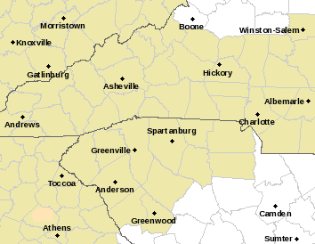
The highlighted area is the Special Weather Statement concerning the snow, near Charlotte.
https://forecast.weather.gov/wwamap/wwatxtget.php?cwa=gsp&wwa=special%20weather%20statement
Thanks to Kenneth Lund for this link
“Sure hasn’t warmed up here in the last 70 years!” says Kenneth.
The post Snow in South Carolina – In early April appeared first on Ice Age Now.
via Ice Age Now
April 2, 2019 at 05:05PM
