
Reposted from the Cliff Mass Weather Blog
Saturday brought record or near-record cold temperatures to the Pacific Northwest, and strangely enough, that led to unusual Diablo winds over northern California, with the regional utility PG&E cutting power to thousands to reduce the chance of another major wildfire.
Cold temperatures potentially producing wildfires? Ironic, perhaps, but true.
Late last week an unusual slog of cold air, connected with an upper level trough, pushed into the Pacific Northwest, with the cool, dense air associated with high pressure at low levels. That cold air/high pressure combo extended inland and then southeastward into the Intermountain West (from eastern Oregon down into Nevada). And high pressure north and east of California resulted in strong, dry downslope, northerly to easterly flow that can produce dangerous wildfire conditions: the feared Diablo winds. Let me illustrate this for you!
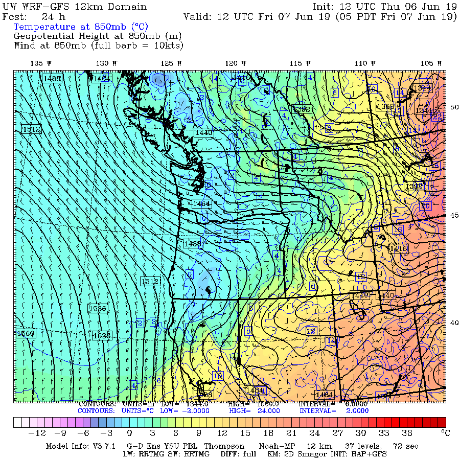
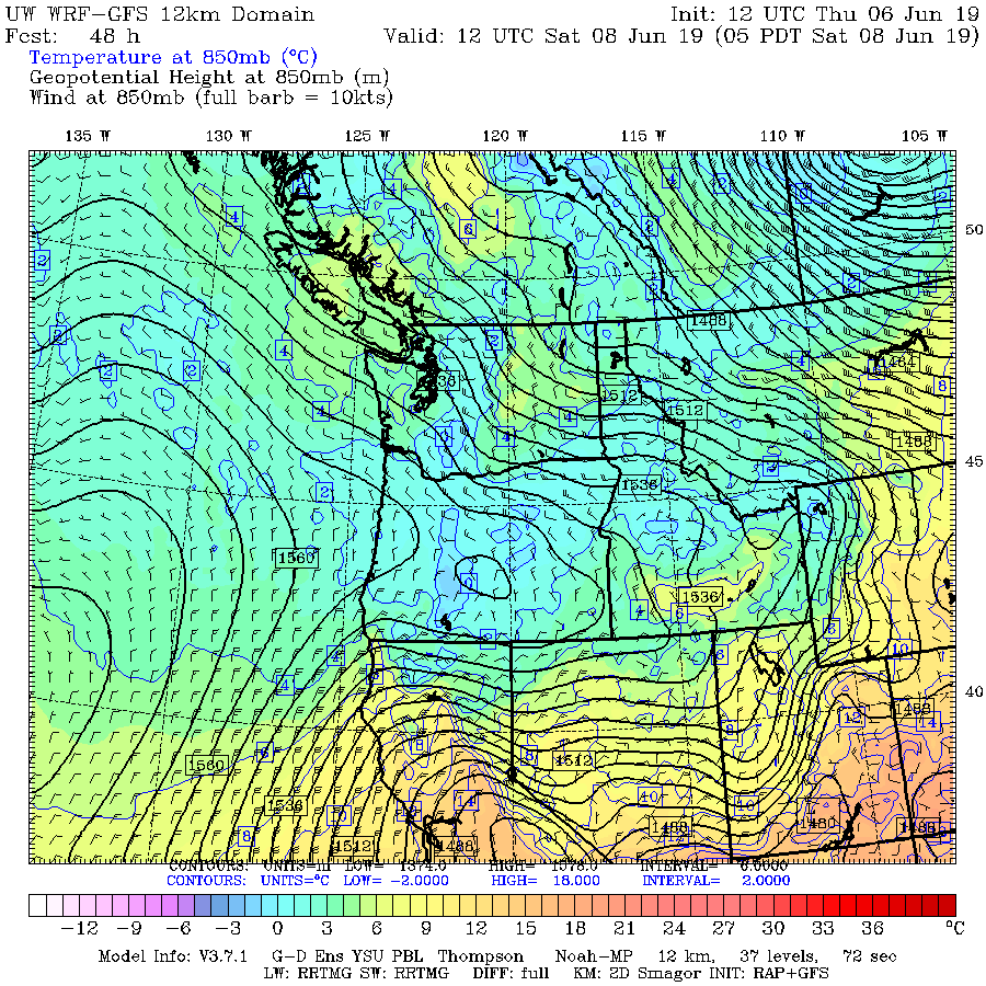
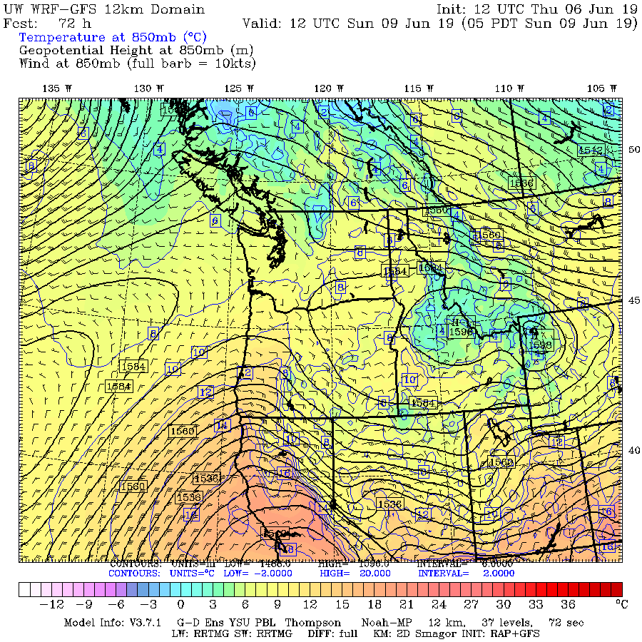
Below are a series of model forecasts during the period in question, including heights ( think pressure, solid lines), winds, and temperatures around 5000 ft (actually the 850 hPa pressure level).
At 5 AM Thursday, the cold air was starting to move in (bluish colors).

A day later (5AM Friday), the cold air was pushing inland.
Saturday morning at 5 AM, higher heights (and pressure) and cool air had extended into Oregon, with a very strong pressure (height) gradient over northern CA and Nevada. Strong pressure gradients produce strong winds!
And by Sunday at 5 AM, the high pressure (and still cool air) pushed farther east and south, leaving a very strong pressure/height gradient across the Sierra Nevada and northern CA. Lower heights and pressure are along the coast. This is exactly the pattern that produces the dry, windy conditions called Diablo winds, that have been associated with major CA wildfires, such as the Nov. 2018 Camp and Oct. 2017 Wine Country fires. No wonder PG&E decided to shut off the power in some communities.
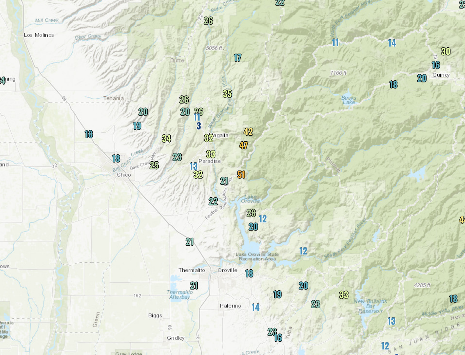
In fact, winds did gust to 60 mph in some locations north of San Francisco (see below)
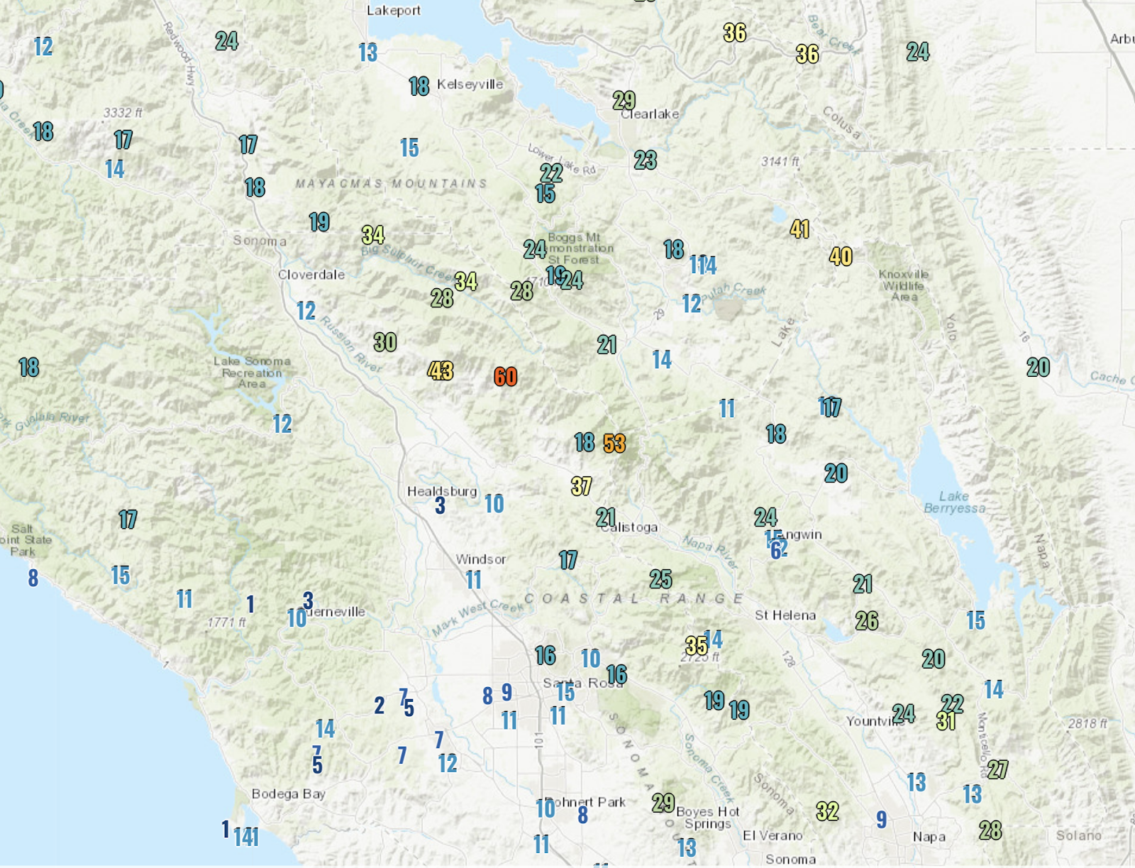
And over 45 mph gusts hit north and east of Paradise, CA, the location of the horrific Camp Fire last year. With a poor power infrastructure, PG&E has to shut the power off to prevent their power lines from starting new fires. One helpful thing this time of the year–vegetation is still relatively green, particularly after a very wet spring.
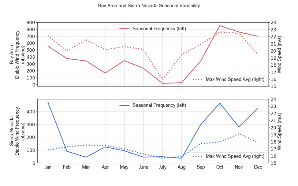
Having such strong Diablo winds is very unusual this time of the year, since normally these strong downslope winds avoid the summer.
Why? Because they are driven by cold, inland high pressure that is rare during the summer. To show this, here is a figure from a paper on Diablo winds written by UW grad student Brandon McClung and myself (I have a NSF grant to study Diablo winds, by the way). Diablo winds on the western side of the Sierra Nevada are rare in mid-June and infrequent around the Bay Area. Big increase in fall as cool air moves inland.
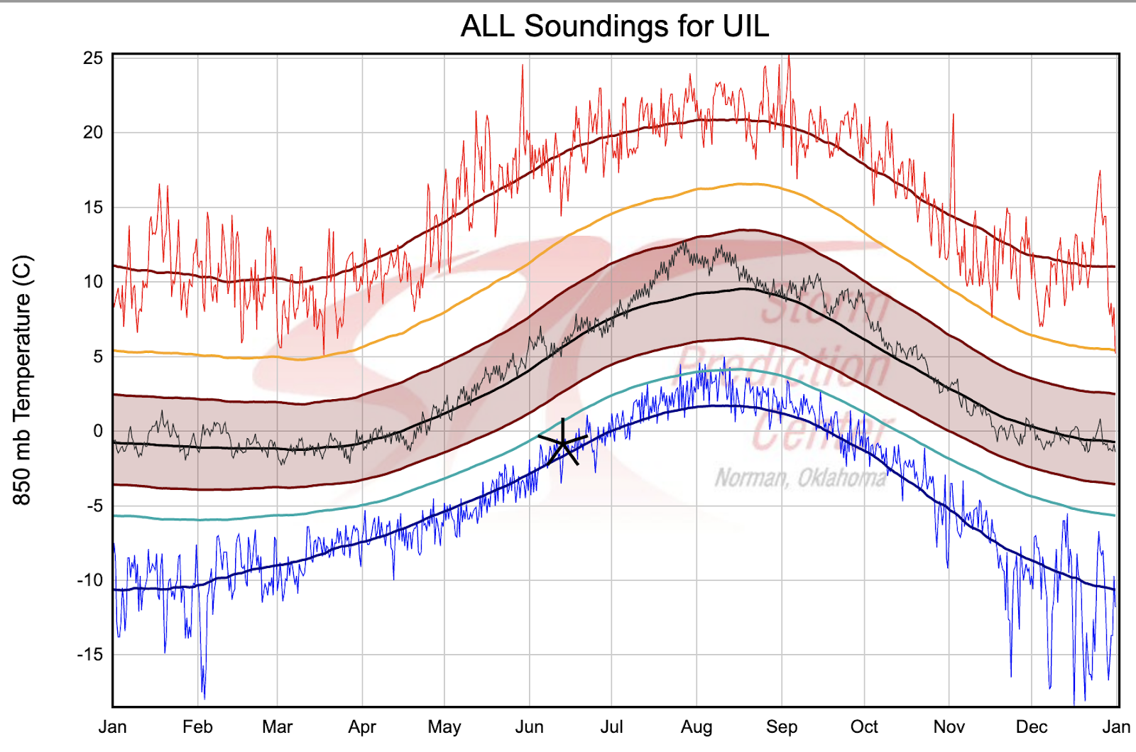
So why the unusual June Diablo winds this year? Unusually cold temperatures. Here is the climatological of temperatures at 850 hPa (again around 5000 ft) at Quillayute, on the Washington coast, versus time of the year. The blue lines represent the record low temperatures for the date. I put a marker on Friday’s value—pretty much tied the record low. No wonder there was snow at the Paradise ranger station on Mt. Rainier on Friday and early Saturday!
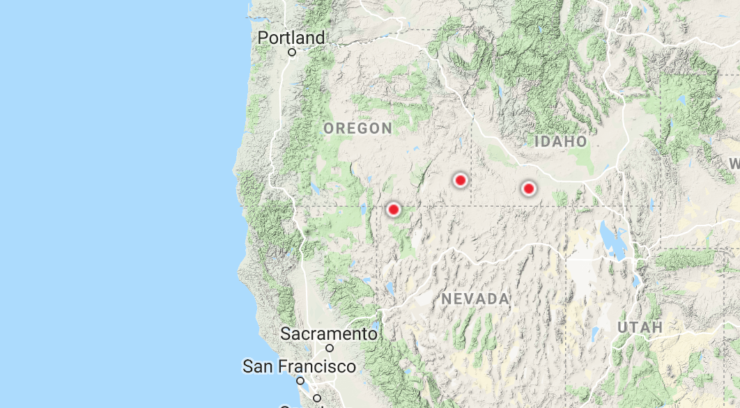
But the temperatures were even more unusual in Oregon and vicinity. This map, courtesy of NOAA, shows locations of record low maximum temperatures on Friday for that date. LOTS of them over southern Oregon and Idaho.

And there were even some record low minimum temperatures for that date as well.
Even more impressive, there were some MONTHLY records for low maximum temperatures. THAT is very unusual.
So the potential for major wildfires in CA is directly associated with colder than normal temperatures extending into the Pacific Northwest and into Nevada. Even more interesting, global warming, which would probably reduce such cold-air periods, could well reduce the number of Diablo winds and thus wildfire threat periods like this event. This is something I am researching using high resolution regional models run for a century.
via Watts Up With That?
June 10, 2019 at 04:09PM

Reblogged this on Climate- Science.
LikeLike