| TOTAL |
|
148.4 |
141.2 |
There was about two inches of rain on the Sunday, the 28th, but this was compounded by another couple of inches on the Wednesday.
As we have seen, two inches a day is not an uncommon event anywhere in England, and particularly in Pennine areas.
The best long term record we have in the area is at Buxton, itself about five miles from Whaley Bridge. (It is Buxton where I am trying to get the data from the Met Office for!)
As we can see from the KNMI database below, there have been 90 days with rainfall over 40mm since 1920, effectively one a year on average.

http://climexp.knmi.nl/gdcnprcp.cgi?id=someone@somewhere&WMO=UKE00105905&STATION=BUXTON&extraargs=
By far the worst day was 15th July 1973, when 87.5mm fell. Buxton was by no means the only place affected that month:


https://digital.nmla.metoffice.gov.uk/digitalFile_762a06ee-a2fd-4aaf-a292-b159c795fccf/
Obviously the coincidence of two heavy rainfall days around Whaley Bridge last week turned a regular event into an exceptional one, but even then not that unusual.
Over the 7-day period leading up to the dam failure, Longley Bottom received 148mm of rain. Again using the Buxton database, we can track other similar events:

There have been seventeen years where 7-day rainfall exceeded 120mm. The worst was in October 1998. In the week leading up to the 28th, 216mm fell, including two days with 58mm, one of 34mm and another of 25mm.
One of the issues with the dam last week was that it was apparently already nearly full before the rains fell. I am not in the least surprised as our dams on the Yorkshire side have been full for months as well.
But it does beg the question, why are these dams kept at maximum levels, especially when the Met Office has given ample warning of heavy rains? After all, part of the function of dams is to regulate water flow downstream. This can involve storing water for when needed in drought. But it also means reducing flows at times of heavy rainfall by storing water in the dams.
Certainly, if the dam levels had been kept sensibly below maximum capacity at Toddbrook before last week’s rains fell, the problems with the spillway would not have occurred. But also downstream areas would have been protected from flooding as well.
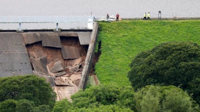
As for the dam itself, even the BBC are now questioning whether the spillway itself was at fault:
Heavy rainfall caused water levels in the reservoir to rise and start flowing over the auxiliary – or emergency – spillway.
The structure failed and was partly eroded away by water flowing over it.
Alan Warren, chairman of the British Dam Society, said the cause was unclear.
"We don’t know whether the concrete was inadequate or whether there was some problem underneath those concrete slabs which means the slabs fell into a void that had been forming underneath," he said.
"Maybe the joints in the slabs weren’t properly sealed, and water was getting in through the joints."
Mr Coackley said photos suggested water had washed away soil beneath the slabs but the clay core was still intact.
"That’s why the dam is still secure there at this stage," he said.
https://www.bbc.co.uk/news/uk-england-derbyshire-49196766


Reblogged this on Climate- Science.
LikeLike