
By Paul Homewood
The Atlantic Hurricane season has now officially ended, and as usual there is the usual wilful misreporting:
https://www.cbsnews.com/miami/news/above-normal-2023-atlantic-hurricane-season-ends/
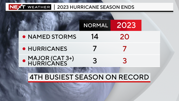
As even CBS own chart shows, the number of hurricanes and major hurricanes has only been average.
Instead it is those named storms, which did not reach hurricane strength, that have been above average. And as we know, this is simply because we are able to spot many more of these short lived, weak storms with the help of satellites, along with the fact that many storms are now named which would not have been categorised as Tropical Storms in the past.
First, let’s look at the actual data.
The best record we have is for US landfalling hurricanes, with reliable data back as far as the 1900. According to the US Hurricane Research Division (HRD):
Because of the sparseness of towns and cities before 1900 in some coastal locations along the United States, the above list is not complete for all states. Before the Gulf of Mexico and Atlantic coasts became settled, hurricanes may have been underestimated in their intensity or missed completely for small-sized systems (i.e., 2004’s Hurricane Charley).


https://www.aoml.noaa.gov/hrd/hurdat/All_U.S._Hurricanes.html
This year there has been one hurricane, Idalia, a Cat 3. The 30-yr average is 2.4 and 1.4 for all hurricanes and major ones respectively.
According to NOAA’s latest assessment published last month:

https://www.gfdl.noaa.gov/global-warming-and-hurricanes/
This statement is borne out by both the US data above, and the Atlantic basin data below:


https://www.aoml.noaa.gov/hrd/hurdat/comparison_table.html
The number of both all Atlantic hurricanes and major ones this year, seven and three, is just below the 30-yr average of 7.5 and 3.4.
Both US and Atlantic-wide data show a dip in hurricane activity during the 1970s and 80s. This is associated with the cold phase of the AMO:

https://www.aoml.noaa.gov/phod/faq/amo_faq.php
NOAA additionally suggest that increasing frequency since the 1970s may be due to reductions in aerosols from human activity and volcanic forcing.
It is also worth looking at the central pressure of hurricanes when they made US landfall, as this gives us the best assessment of intensity:

https://www.aoml.noaa.gov/hrd/hurdat/All_U.S._Hurricanes.html
Idalia had pressure of 949mb, so did not make the list of the strongest, which offers no evidence whatsoever that hurricanes are becoming stronger.
So having established that the Atlantic hurricane season was perfect normal, why is the number of tropical storms higher than average?
There were only two US landfalling storms this year, Harold & Ophelia, and there is certainly no long term increasing frequency of them:

https://www.aoml.noaa.gov/hrd/hurdat/uststorms.html
In stark contrast, we see a dramatic increase in the number of Atlantic tropical storms since 1980:

https://www.aoml.noaa.gov/hrd/hurdat/comparison_table.html
And this strongly points the finger at changing observational practices out in the middle of the Atlantic.
Even the BBC, in a lapse of its usual editorial standard, admitted a couple of years ago:
Over the past 10 to 15 years, though, named storms have formed prior to the official start about 50% of the time.
And the way they are defined and observed has changed significantly over time.
"Many of these storms are short-lived systems that are now being identified because of better monitoring and policy changes that now name sub-tropical storms," Dennis Feltgen, meteorologist at the US National Hurricane Center (NHC) told BBC Weather.
The number of named storms has increased over the decades, but there is no real evidence this is the result of a warming world.
The overall increase from 1961 is also likely to be due to better technology, along with observations over the Atlantic Ocean.
Since satellites came along in the 1980s, we can spot and monitor the development of tropical cyclones and name them when they meet the threshold.
We are simply able to record more.
As well as better satellite coverage, there has been an increasing tendency in recent years to “name storms”, which in the past would not have been.
Dr Neil Frank, who was Director of the US National Hurricane Center from 1974 to 1987 goes further, maintaining that many of the storms now named would not have been in his day.
He made two particular complaints about current methods in 2021:
1) Many named storms are actually winter storms, not tropical storms. He states that the first six tropical storms in 2020 would not have been counted in his time.
2) Nowadays the NHC rushes to name a storm, simply based on wind speeds. His team would have waited until the central pressure dropped to confirm that it really was a tropical storm, and not just a thunderstorm. This often explains why named storms are often so short lasting now.
Just because we now name all storms does not mean that there are actually more than when we did not!
NOTE
I need to make clear that these “named storms” are tropical storms/cyclones, and not the storms which cross the UK and which are routinely given silly names by the Met Office.
via NOT A LOT OF PEOPLE KNOW THAT
December 1, 2023 at 08:12AM
