Month: September 2024

September Outlook Arctic Ice 2024

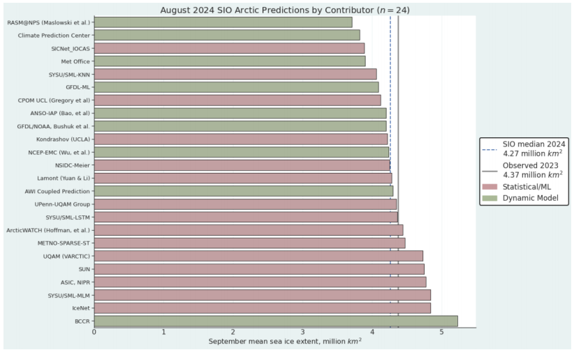
Figure 1. Distribution of SIO contributors for August estimates of September 2024 pan-Arctic sea-ice extent. No Heuristic methods were submitted in August. “Sun” is a public/citizen contribution. Image courtesy of Matthew Fisher, NSIDC.

2024: August Report from Sea Ice Prediction Network

The August 2024 Outlook received 24 pan-Arctic contributions (Figure 1). This year’s median
forecasted value for pan-Arctic September sea-ice extent is 4.27 million square kilometers with
an interquartile range of 4.11 to 4.54 million square kilometers. This is lower than the 2022 (4.83
million square kilometers) and 2023 (4.60 million square kilometers) August median forecasts
for September. . .This reflects relatively rapid ice loss during the month of July, resulting in August
Outlooks revising estimates downward. The lowest sea-ice extent forecast is 3.71 million square
kilometers, from the RASM@NPS submission); the highest sea-ice extent forecast is 5.23
million square kilometers, submitted by BCCR.

These are predictions for the September 2024 monthly average ice extent as reported by NOAA Sea Ice Index (SII). This post provides a look at the 2024 Year To Date (YTD) based on monthly averages comparing MASIE and SII datasets. (18 year average is 2006 to 2023 inclusive).

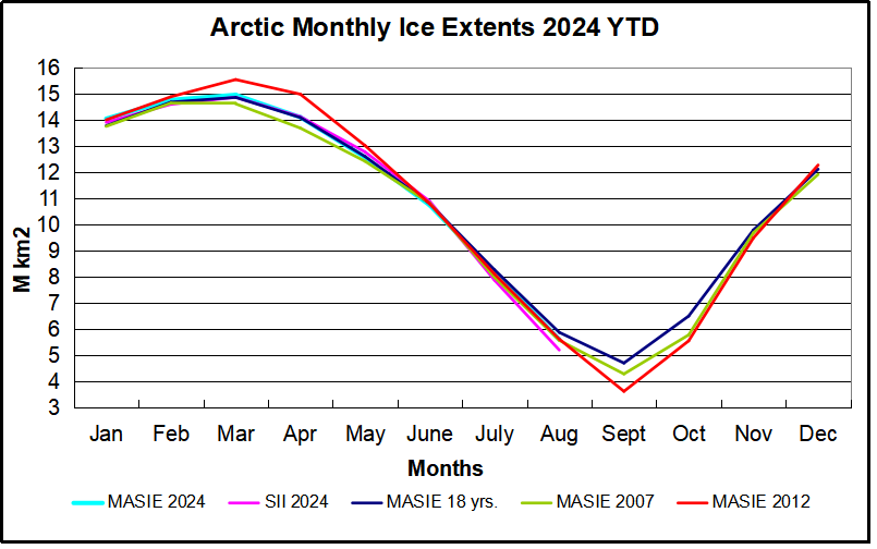
The graph puts 2024 into recent historical perspective. Note how 2024 was slightly above the 18-year average for the first 5 months, then tracked slightly lower to average through August. The outlier 2012 provided the highest March maximum as well as the lowest September minimum, coinciding with the Great Arctic Cyclone that year.  2007 began the period with the lowest minimum except for 2012.  SII 2024 started slightly higher than MASIE the first 3 months, then ran the same as MASIE until dropping in August nearly 400k km2 below MASIE 2024 and also lower than 2007 and 2012.

The table below provides the monthly Arctic ice extent averages for comparisons (all are M km2)

Monthly MASIE 2024 SII 2024 MASIE -SII MASIE 2024-18 YR AVE SII 2024-18 YR AVE MASIE 2024-2007
Jan 14.055 13.917 0.139 0.280 0.333 0.293
Feb 14.772 14.605 0.167 0.096 0.152 0.121
Mar 14.966 14.873 0.093 0.111 0.199 0.344
Apr 14.113 14.131 -0.018 0.021 0.118 0.418
May 12.577 12.783 -0.207 -0.038 0.123 0.150
June 10.744 10.895 -0.151 -0.072 0.024 -0.082
July 8.181 7.884 0.297 -0.107 -0.160 0.188
Aug 5.617 5.214 0.404 -0.267 -0.423 0.033

The first two data columns are the 2024 YTD shown by MASIE and SII, with the MASIE surpluses in column three.  Column four shows MASIE 2024 compared to MASIE 18 year averages, while column five shows SII 2024 compared to SII 18 year averages.  YTD August MASIE and SII are below their averages, SII by nearly half a Wadham. The last column shows MASIE 2024 holding surpluses over 2007 most of the months, and nearly the same in August.

Summary

The experts involved in SIPN are expecting SII 2024 September to be much lower than 2023 and 2022, based largely on the large deficits SII is showing in July and August. The way MASIE is going, this September looks to be lower than its average, but much higher than SII.  While the daily minimum for the year occurs mid September, ice extent on September 30 is typically slightly higher than on September 1.

Footnote:

Some people unhappy with the higher amounts of ice extent shown by MASIE continue to claim that Sea Ice Index is the only dataset that can be used. This is false in fact and in logic. Why should anyone accept that the highest quality picture of ice day to day has no shelf life, that one year’s charts can not be compared with another year? Researchers do this, including Walt Meier in charge of Sea Ice Index. That said, I understand his interest in directing people to use his product rather than one he does not control. As I have said before:

MASIE is rigorous, reliable, serves as calibration for satellite products, and continues the long and honorable tradition of naval ice charting using modern technologies. More on this at my post Support MASIE Arctic Ice Dataset

MASIE: “high-resolution, accurate charts of ice conditions”
Walt Meier, NSIDC, October 2015 article in Annals of Glaciology.

via Science Matters

https://ift.tt/xuUvONo

September 10, 2024 at 12:20PM

Tropical Storm Francine Arrives – Just in Time

Brief News Note by Kip Hansen  —  9 September 2024

Just in time to beat the “hurricane season peak  deadline”, NOAA’s National Hurricane Center declared the Potential Tropical Storm Six to be Tropical Storm Francine:

10:00 AM CDT Mon Sep 9

Location: 23.0°N 94.9°W

Moving: NNW at 5 mph

Min pressure: 1002 mb

Max sustained: 50 mph

From the Discussion section: 

“Tropical Storm Francine Discussion Number   4

NWS National Hurricane Center Miami FL       AL062024

1000 AM CDT Mon Sep 09 2024

The structure of the system on satellite imagery has improved this

morning, with a large circular region of cold convection between -70

to -85 near the estimated center. An Air-Force Reconnaissance

Aircraft is sampling the system this morning and earlier found a

cyclonic wind shift from southeasterly to northwesterly flow near

the center of the mass of deep convection. This data provides enough

evidence that a well-defined circulation now exists, and thus PTC

Six has become Tropical Storm Francine with sustained winds of   

45 kt this advisory.

The estimated motion is still tricky given the center only recently

formed but is estimated still off to the north-northwest at    340/4

kt. The system is expected to gradually turn northward and then

north-northeastward as it moves between a mid-level ridge centered

over Cuba and a broad mid- to upper-level trough located to its

northwest over Texas. The guidance this cycle has shifted a little

eastward and faster, and the NHC track forecast was once again

nudged in that direction. The current track splits the difference

between HCCA and TVCN and still shows Francine moving ashore of

Louisiana sometime on Wednesday evening. There remains a decent

amount of track uncertainty with the GEFS and EPS ensembles showing

along-track spread implying some speed differences near landfall.

While the system is now a tropical storm, the inner core wind field

per reconnaissance observations is still broad and in the organizing

stage, and initial intensification will be gradual. However, after

an inner-core becomes established, and assuming the cyclone’s

vertical structure becomes aligned, a period of more significant

intensification is possible while storm is embedded in a low shear,

high mid-level moisture, and over very warm 30-31 C sea-surface

temperatures.  The SHIPS rapid intensification (RI) indices are

pretty elevated, and a period of RI could also occur between   24-48

h. For now, the NHC intensity forecast will not explicitly forecast

RI, but is higher than the previous cycle and shows a 75 kt peak in

48 h, in good agreement with the intensity consensus aids. After

that period, southwesterly vertical wind shear quickly increases

from 10 kt to more than 30 kt and the intensity could plateau as it

approaches the northwestern U.S. Gulf coastline, though the system

is forecast to remain a hurricane at landfall. The NHC intensity

forecast continues to be in good agreement with the consensus aids,

but is a bit under the HAFS-A/B and COAMPS-TC models.

Given the latest forecast, a Hurricane Watch has been issued for

the Louisiana coastline from Cameron to Grand Isle, and a Storm

Surge Watch has been issued from High Island, TX eastward to the

Mississippi/Alabama Border.”

Thus, for the season to date we now have this:

# # # # #

Author’s Comment:

Compared to the historical record, the 2024 Hurricane season is running at a little less than 50%.

The Two-Day and Seven-Day forecasts show a couple of things in the pipeline – which may develop into tropical storms.

And that’s the news.

# # # # #

via Watts Up With That?

https://ift.tt/r64yId0

September 10, 2024 at 12:01PM

September Snowmageddon… Winter Outbreak In Alps Later This Week…Up To 3 Meters Of Snow!

German online weather site Das Wetter here reports: “Up to 3 meters of fresh snow is possible at high altitudes in the Alps” and: “Even in Garmisch-Partenkirchen and Oberstdorf it could turn white beginning Friday.”

Europe had been basking in late summer warmth, but the weather is now changing dramatically as a so-called Vb weather situation is poised “to put large parts of the region in a state of emergency.”

Some weather models are showing 200 to 400 liters of rain and snow per square meter within 7 days. The Alps and parts of Eastern Europe are expected to be hard hit by flooding especially on parts of the Czech republic and Poland.

“The sudden cold snap means that snow is already falling in the Alps from 1000 meters upwards. And not in short supply: up to 3 meters of fresh snow is possible at high altitudes – conditions that are only known from the depths of winter. Places like Oberstdorf and Garmisch-Partenkirchen are particularly affected, with heavy snowfall expected on Friday and Saturday,” reports Das Wetter.

Such massive amounts of snow could mean that the ground won’t be seeing daylight until next summer.

“Severe winter outbreak”

Meanwhile, German meteorologist Dominik Jung today reports at his daily video update of “a severe winter outbreak” for the Alps.

“Snow could fall at elevations down to 1000 meters. Friday and Saturday morning, snow is possible down to 700 meters above sea level,” reports Jung, noting that this is “relatively early” for this time of year.

“Snow this low in the mountains this time of the year is rather unusual. Snow down to 1000-1500 meters happens occasionally. But at 700 meters, it’s more of an exception,” says Jung.


via NoTricksZone

https://ift.tt/UT0RlDt

September 10, 2024 at 10:29AM

Morano on Fox & Friends on Harris’s plastic straw ban reversal & collapsing EV sales & offshore wind fiasco

WATCH NOW: Vice President Harris is flip-flopping on yet another issue: banning plastic straws.

via CFACT

https://ift.tt/e4Bc8AY

September 10, 2024 at 10:16AM