
0 out of 10 based on 0 rating
via JoNova
October 31, 2024 at 09:47AM
An undated Earth.com article claims “The foundation of life is at risk from climate change.” This is false. Real-world data shows that the Earth is actually increasing its biomass in response to the mild warming over the last century combined with increases in atmospheric carbon dioxide.
The article itself is nothing more than a mishmash of statements, none of which, separately or in combination, support the claim that climate change is threating life on Earth, as the title implies. There is only a vague statement in the first paragraph which reads:
Photosynthesis forms the foundation of life on Earth, yet climate change increasingly threatens this essential process. With advanced tools, scientists can now study how shifts in temperature, humidity, and light impact photosynthesis and, by extension, the future of ecosystems.
It is true that “[p]hotosynthesis forms the foundation of life on Earth.” Photosynthesis is considered the foundation of life on Earth because it provides the oxygen we breathe and the food we eat, essentially acting as the base of the global food chain by converting sunlight, water, and carbon dioxide into chemical energy that sustains almost all living organisms on the planet.
But what isn’t true is the claim that climate change is threatening the process of photosynthesis. In fact, data from multiple sources show that photosynthesis is actually being enhanced by the slight increase in temperature as well as the increased concentration of carbon dioxide in Earth’s atmosphere. Climate at a Glance – Global Greening, discusses the fact that NASA satellite imagery analysis from 2016 shows significant plant growth globally over the past 35 years as seen in Figure 1 below. The reference article also says:
Research from NASA as well as multiple other studies conclude that the increased plant growth is a response to rising carbon dioxide in Earth’s atmosphere creating better growing conditions.
NASA’s results confirm earlier research which found that the 14 percent increase in atmospheric CO2 between 1982 and 2010 resulted in a 5-to-10 percent increase in green foliage cover in warm, arid environments.
Plant life is not just expanding in temperate regions. A 2018 study found the Sahara Desert had shrunk in area by 8 percent over the previous three decades, due a CO2 fertilization induced expansion of plant coverage.
Follow-up studies in 2018 and 2020, showed that on a global scale, greening can be attributed to the increase of carbon dioxide in the atmosphere.

This is logical, because actual greenhouses use warmth and artificially increased carbon dioxide to provide a better growth environment for the plants. These facts are not in dispute, therefore it stands to reason that a slightly warmer Earth and with more carbon dioxide in the atmosphere, all things being equal, provides a better environment for plant growth. Not only that, but a very recent peer reviewed paper published in Nature from Cornell University and the Department of Energy’s Oak Ridge National Laboratory found that Plants Absorb 31% More CO2 Than Previously Thought.
These findings refute the claims made in Earth.com’s article and headline photosynthesis and life on Earth are being “threatened.”
This isn’t truly surprising because the article itself provides no factual evidence to support its alarming claims. Earth.com’s article appears to be just another example of sloppy journalism in which a writer stitched together a few unrelated factoids about photosynthesis to make the article look “sciency,” only to leap to unsupported and false assertions that climate change is hampering photosynthesis and threatening life on Earth, when, in fact, there isn’t even a smidgen of evidence to support the claim. Earth.com did its readers a great disservice by pushing this false claim, which appears to be little more than a scare tactic.
Anthony Watts is a senior fellow for environment and climate at The Heartland Institute. Watts has been in the weather business both in front of, and behind the camera as an on-air television meteorologist since 1978, and currently does daily radio forecasts. He has created weather graphics presentation systems for television, specialized weather instrumentation, as well as co-authored peer-reviewed papers on climate issues. He operates the most viewed website in the world on climate, the award-winning website wattsupwiththat.com.
via Watts Up With That?
October 31, 2024 at 08:06AM
By Paul Homewood

https://www.thesun.co.uk/news/31400639/spain-flooding-map-areas-worst-hit/
As the waters recede, we need to put the Valencia floods into perspective.
According to Wikipedia:
Starting on 29 October 2024, a "gota fría (cold drop)" brought drastic flash flooding to southern and south-eastern Spain, primarily in the Valencia region. Chiva saw nearly 500 millimetres (20 in) of rainfall,[4] while Utiel and Turís each recorded totals of 200 mm (7.9 in), with other southeastern municipalities receiving 100 mm (3.9 in).[5] In Andalusia, the storm caused landslides[6][7] and damage to buildings, roads, bridges and agricultural land.[8][9][10]
On October 30, 2024, the 1973 New Turia Riverbed surged to capacity, sparing Valencia’s city proper but worsening the catastrophic flooding across towns and suburbs to the south due to a funnel effect.[13]
The South Plan [es], the new riverbed for the Turia built after it catastrophically flooded in 1957 prevented flooding in Valencia,[14] but it caused all municipalities to its south to flood, causing tens of deaths in towns like Paiporta.[13] Floods ended up affecting all population centers in Horta Sud, as well as most in Camp de Túria and in Requena-Utiel.[15][16]
The resulting floodwaters caused the deaths of at least 95 people,[1] including 92 in the province of Valencia,[17] two more in Castile-La Mancha[18] and one in Andalusia.[19][20] Dozens of others were also missing.[21] The flooding also caused significant damage to buildings and infrastructure, sweeping away roads and cars while also derailing a high-speed train carrying nearly 300 people, resulting in no injuries.[22]
https://en.wikipedia.org/wiki/October_2024_Spain_floods
As the Sun’s map indicates, rainfall peaked at around 180mm for the three-day duration of the storm, though likely higher in the hills where reliable measurements are not available, either now or in the past. This would appear to be confirmed by figures of 200mm at Utiel and Turis.
Wikipedia make reference to the 1957 floods, widely regarded as some of the worst in history in Valencia.
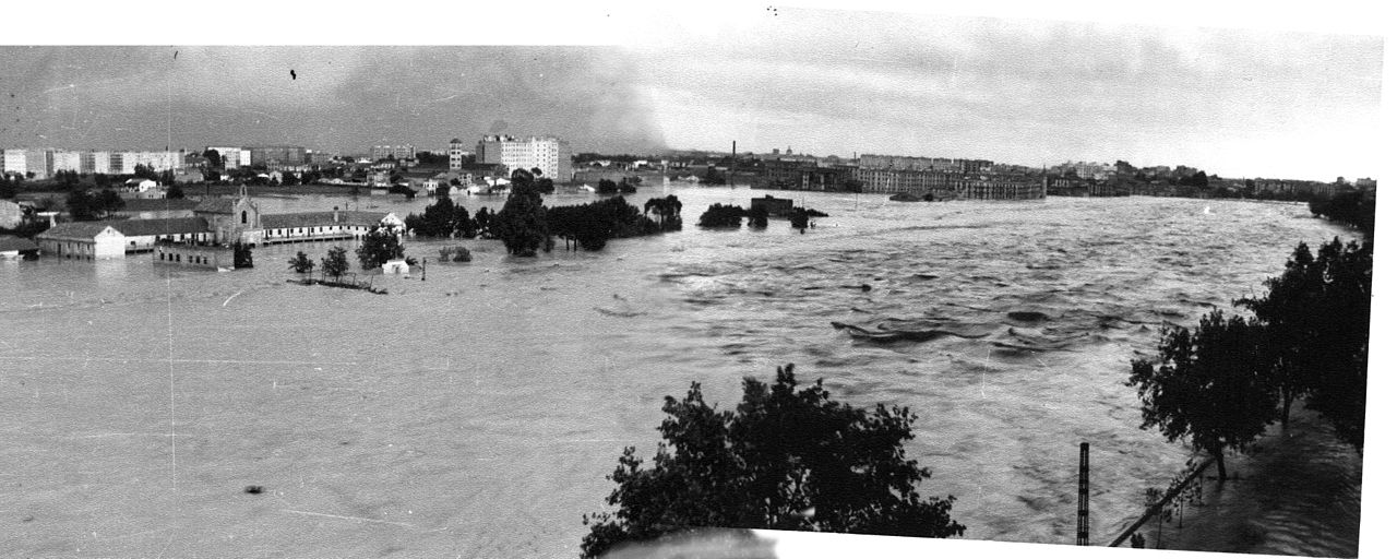
Photo of Valencia’s ‘Great Flood of 57’. Source: Wikipedia
Here is one account:

For most of the year the Turia was a dormant little stream which trickled along the sticky mudflats, which Valencia liked to call a river. Writing at the beginning of the nineteenth century, British writer Richard Ford mocked the Valencians for the false grandeur of their magnificent bridges and high river walls… all for a piffling little brook. What he didn’t know was that twice a year the river swelled with the autumn and spring rain or that every ten years or so it flooded the city. It was a supposedly normal Monday in 1957 in Valencia. On October 14th a flood came, which caused such devastation it was to be an historic turning point in the way the city developed. It helped shape what we know as Valencia today.
Valencians knew that you tended to get a bit of rain in these parts around October time but no one could have imagined the scale of the tragedy which was about to befall them. On the Saturday, two days before the flood, was the festival of Pilar. There had been heavy rain and the scheduled bullfight had been cancelled. Sunday morning, however, had seen only a few showers catching people on their way to Mass. The afternoon had been dry, Levante’s match against Tetuán had gone ahead and people crowded into the city’s numerous cinemas. In a curious twist of fate, one of the most popular films that weekend was the disaster movie ‘Typhoon over Nagasaki’ at the ‘Olimpia’. They needn’t have bothered going to the pictures, it was all about to happen right in front of their eyes.
While people were turning in for the night, some of the heaviest rains ever seen had been falling further inland and some night owls marvelled at how the river had swollen. Not long after midnight, the first wave struck. At a rate of two thousand seven hundred cubic metres per second, water poured into the city. Within minutes, houses around Calle Alboraya and Calle Sagunto were letting in up to a metre of water. People scrabbled their way to upper floors, climbed trees and statues, the lights went out and the violent rush of water could be heard all over the city.
This first wave only affected people who lived in the vicinity of the river, especially along its North bank and nearer the sea at Malvarrosa and Nazaret. The ancient doors of the Monasterio de la Trinidad were wrenched off by the force of the water. Things calmed down at around 4 a.m. During that morning, people from the centre (as yet unaffected) ventured out to see the fast-flowing water and the eerie sight of drowned cows, floating down to the sea from a cattle farm further upstream. The Pont de Fusta (or wooden bridge) in front of the Estación del Puente de Madera had been completely washed away. Little did they know the worst was yet to come.
At around two in the afternoon, a second wave crashed in. It was bigger than the first, at nearly four-thousand cubic metres per second. The river recovered its ancient course through the city centre, which had been dry since the eleventh century. Vast waves of water flowed furiously into the Barrio Carmen down Calle Baja, through to Bolseria, past the Central market, across the Plaza del Ayuntamiento and out again down Calle Barcas, a street which had originally taken its name from an ancient landing stage when the river had previously flown through the city. Most of the centre was under three metres of water, the worst hit areas were again on the North bank, Calle Doctor Oloriz was under more than five metres. Despite being close to the river, the Cathedral and the whole of the old Roman city was left completely untouched becoming once again the ancient island on which the city was founded.
The true death toll is unknown but official figures state that more than a hundred people lost their lives. Many more lost their homes, belongings and livelihoods in the case of some shopkeepers and traders. One body, found on the wall of the Viveros gardens after the waters had subsided, was that of Micaela Chulvi Benaches who hadn’t been killed by the flood at all. She had died of old age at 84 and was lying in state in the family living room when the waters washed her away. One man who had been trapped on the Puente de la Trinidad had climbed onto the head of the Statue of Santo Tomás de Villanueva to escape drowning. After holding on for more than two hours, he was finally thrown a rope and rescued to great cheers from the watching crowds. Many people had saved themselves by holding onto the railings and climbing up to first floor balconies along the Calle Barcas but the city itself would never be quite the same again.
The clear up began almost immediately and help came from all over Spain. The first to arrive was the Cartagena fire brigade from Murcia. Those doing military service in 1957 & 1958 were brought in to clean the city, spending most of their time up to their knees in the vast amounts of mud and sludge that the floods had left behind; they were known as the Quinta del fango “the mud generation”. New housing was built in the middle of the fields, which are now Avenida Blasco Ibáñez for those who had been made homeless. The development was named after l’Alguer in Sardinia. Rising up as it did in the middle of the Huerta it quickly became known as “La Isla perdida” (the lost island).
The river was diverted and a new river bed with a capacity to handle water flowing at up to 5,000 cubic metres per second was built to the south of the city. Just in case, the south wall of the new river is slightly lower so any future flood would flow south, away from the city. What the residents of Sedaví, Benitusser and Torrente thought of this at the time is not known.
After twenty years of bickering about what to do with the old riverbed, some bright sparks wanted to build a huge motorway right down the middle. Thankfully, the plan did not come to fruition. Work finally started on the Turia park as a public green space, running right through the city, still known universally as “the river.” Subsequently, most significant public works have been centred on this previously neglected area, including the park itself, the Ciudad de las Ciencias, the Palau de la Musica, the Parque de Cabecera, the Bioparc. As a direct legacy of the flood, the seeds of modern Valencia were sown.
With many of its shops and houses devastated and destroyed, the Barrio Carmen was never again to recover its role as the business and commercial centre of the city. The shops and businesses moved out first to La Avenida del Oeste and later to Calle Colón. The last remaining aristocrats abandoned their crumbling Carmen palaces and joined the upper middle classes around the Gran Via and the barrio was left to rot. This may not have been such a bad thing. While the Calle Colón has lost all but a few of its original buildings to huge department stores & chains & franchises…the Carmen has been preserved in all its intricate, dusty, dilapidated splendour. Had it not been for the flood we might have had a huge concrete ‘El Corte Inglés’ built right in the middle of the Plaza de la Virgen or over what, thankfully, is still old Calle Caballeros.
https://247valencia.com/la-riada-the-flood-of-valencia/
Note the comment:
“While people were turning in for the night, some of the heaviest rains ever seen had been falling further inland “
KNMI confirm that 186mm of rain fell on Valencia over the three day period, including 125mm on the 14th. But this was evidently much less than fell inland. And as KNMI also show, daily totals of 120mm or more are not unusual there:

There is another relevant similarity to the 1957 flood, which as was also the result of a “Cold drop”:

https://en.wikipedia.org/wiki/1957_Valencia_flood
A cold drop is a very common meteorological phenomenon in these parts, and as the BBC reported, it was this DANA event which made the storm so much worse this time:

https://en.wikipedia.org/wiki/Cold_drop
Valencia has regularly flooded throughout history. One estimate suggest at least 75 floods in the last seven centuries. The floods of 1949 and 1897 also stand out in recent times.
Ironically a year before the 1957 floods, Valencia had its highest daily rainfall on record, 262mm on Nov 17th. This appears to have had less flooding impact, because the waters flowed away downstream. The really bad flooding occurs when heavy rain falls inland, and goes on to be channelled into the River Turia.
There is one final and highly relevant comment I must make. From the 24/7 Valencia article:
“The river was diverted and a new river bed with a capacity to handle water flowing at up to 5,000 cubic metres per second was built to the south of the city. Just in case, the south wall of the new river is slightly lower so any future flood would flow south, away from the city.
And as Wikipedia note, it was this diversion which led to the catastrophic floods to the south of the city:

https://en.wikipedia.org/wiki/October_2024_Spain_floods
It serves as reminder that flood defences more often than not simply transfer problems elsewhere.
via NOT A LOT OF PEOPLE KNOW THAT
October 31, 2024 at 06:12AM

A co-author/professor in the study says: ““It’s very important to have in-depth knowledge of how CO2 is naturally transported, stored and transformed between continents, water and the atmosphere”. In other words, knowledge of nature’s carbon cycle. But to then assert their findings can help with ‘fighting global warming’ is opinion, not science.
– – –
Unlike oceans, lakes are significant emitters of CO₂, says the University of Lausanne (via EurekAlert).
But why is this the case, and what mechanisms are at play?
For the first time, UNIL scientists have successfully explained the complete carbon cycle in Lake Geneva, creating a model that can be applied to several of the world’s largest lakes.
— Contrary to previous beliefs, it is the natural erosion of rocks that is responsible for the significant CO2 emissions from Lake Geneva and many of the world’s large lakes.
— This study provides the missing piece for understanding the carbon cycle in lakes.
— The LéXPLORE lake platform in Switzerland played a major role in this discovery of international significance.
Like most lakes in the world, Lake Geneva is an emitter of greenhouse gases, particularly carbon dioxide (CO2). Annually, it produces as much CO2 as the automobile transport of the city of Lausanne (≃ 150,000 inhabitants).
This phenomenon – the production of CO2 by lakes – has been known for years. There is, however, widespread debate as to the mechanisms at work.
Traditional scientific theories suggest that lake CO2 emissions are primarily due to the influx of organic matter from surrounding soils. This material, originating from the decomposition of plant and animal residues, is carried into the lake by rainfall, where it is broken down by microorganisms, leading to the release of CO2.
This process is known as respiration. While this theory accounts for the behavior of some lakes, it doesn’t apply to Lake Geneva, which receives very little organic matter from its shores.
In theory, its annual carbon balance should be neutral, with winter CO2 production (from organic matter decomposition and water mixing) balanced by summer CO2 absorption (due to algae photosynthesis). So why does Lake Geneva still emit large amounts of CO2?
A team of UNIL scientists has just deciphered the mechanisms involved. Most of the emissions actually come from the natural erosion of rocks in the lake’s upstream basin.
When rainwater hits the rocks, it releases bicarbonate and calcium ions, which then find their way into the lake. In summer, under the effect of heat and the growth of algae – which change the PH of the water and act as a catalyst – the ions form microparticles of limestone. This is known as calcite precipitation.
This chemical reaction releases CO2, giving the lake its milky blue-green appearance in the warm season. Algae continue to absorbCO2, but this is not enough to compensate for the massive production resulting from rock erosion.
The additional emissions are therefore the result of a geological process, not just a biological one, as previously thought.
Full news release here.
– – –
Image: Lake Geneva [credit: discoverwalks.com]
via Tallbloke’s Talkshop
October 31, 2024 at 05:39AM
